عضویت
عضویت  ورود اعضا
 راهنمای خرید


Underground Mapping0 pages
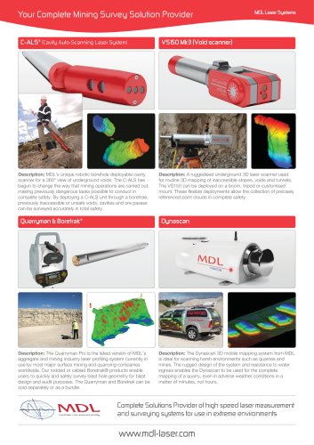
Underground Mapping
Client: Kalgoorlie Consolidated Gold Mines (KCGM)
Project: Underground Workings Detection at the KCG Super Pit
Laser System: C-ALS®
KCGM use underground cavity scanning to map
underground mine workings under the Fimiston
Super Pit to keep personnel and equipment from
being exposed to unsafe ground.
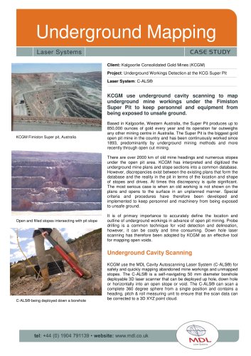
KCGM Fimiston Super pit, Australia
Based in Kalgoorlie, Western Australia, the Super Pit produces up to
850,000 ounces of gold every year and its operation far outweighs
any other mining centre in Australia. The Super Pit is the biggest gold
open pit mine in the country and has been continuously worked since
1893, predominantly by underground mining methods and more
recently through open cut mining.
There are over 2000 km of old mine headings and numerous stopes
under the open pit area. KCGM has interpreted and digitized the
underground mine plans and stope sections into a common database.
However, discrepancies exist between the existing plans that form the
database and the reality in the pit in terms of the location and shape
of stopes and drives. At times this discrepancy is quite significant.
The most serious case is when an old working is not shown on the
plans and opens to the surface in an unplanned manner. Special
criteria and procedures have therefore been developed and
implemented to keep personnel and machinery from being exposed
to unsafe ground.
Open and filled stopes intersecting with pit slope
It is of primary importance to accurately define the location and
outline of underground workings in advance of open pit mining. Probe
drilling is a common technique for void detection and delineation,
however, it can be costly and time consuming. Down hole laser
scanning has therefore been adopted by KCGM as an effective tool
for mapping open voids.
Underground Cavity Scanning
C-ALS® being deployed down a borehole
KCGM use the MDL Cavity Autoscanning Laser System (C-ALS®) for
safely and quickly mapping abandoned mine workings and unmapped
stopes. The C-ALS® is a self-navigating 50 mm diameter borehole
deployable 3D laser scanner that can be deployed up hole, down hole
or horizontally into an open stope or void. The C-ALS® can scan a
complete 360 degree sphere from a single position and contains a
heading, pitch & roll measuring unit to ensure that the scan data can
be corrected to a 3D XYZ point cloud.