عضویت
عضویت  ورود اعضا
 راهنمای خرید


map3D_20130 pages

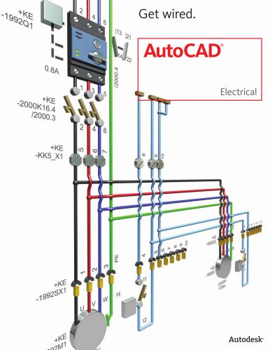
Top Reasons to Buy AutoCAD Map 3D
®
AutoCAD® Map 3D software is a model-based
infrastructure application that provides broad
access to CAD and GIS data, helping GIS,
planning, and engineering professionals
access, evaluate, and share data to make
informed decisions.
1
“ mployees in many of our offices use the
E
maps daily. In the past, they would have
contacted us for the data and waited for
a map or tried to complete tasks without
detailed information. Now, with county data
at their fingertips, they can use it to answer
queries, schedule maintenance, or get project
updates in much more quickly.”
AutoCAD Map 3D includes a rich set of survey tools to
enable you to more easily import, compute, manage,
and utilize field measurements acquired from GPS and
terrestrial sources. The survey functionality includes
the ability to consume custom field codes that can be
mapped to database attributes, making asset collection
more efficient using any device. Other functionality
includes:
Leica® GSI, CPlan RO, ASCII point, and LandXML data import
Survey database and schema
Point groups
Automatic creation of features
—Shawn Olson
GIS Coordinator
Plymouth County, Iowa
“ t’s easier for us to apply business rules based
I
on power transmission standards to our
data. The software can help spot and address
errors intelligently. The software allows us
to edit the data models to better match our
preferences and regional requirements.”
—Zoran Brankovic
GIS Manager
Swissgrid
Better understand existing conditions and create a more
complete base map.
Directly access and edit more information in a familiar
AutoCAD® environment. With access to design, GIS, imagery, point cloud, and business information, you can make
more informed decisions and more easily integrate data
collected in the field via survey and GPS devices in order to
accurately update drawings, maps, and databases.
Easily import, compute, manage, and utilize field
measurements acquired from GPS and terrestrial
sources.
Manage CAD and GIS data in a single
environment.
Overlay GIS and CAD data, and work more efficiently using
standard AutoCAD® commands to directly edit GIS data.
AutoCAD Map 3D’s interoperability with major design and
GIS software means that users can read, write, and convert
data between most standard formats, including SHP, DGN,
and raster data.
2
Apply intelligent industry models and analysis for
better insight.
Improve the value of information with the ability to betteranalyze data. With AutoCAD Map 3D, you can apply industry-specific standards and business process requirements,
using configurable data models for electric, gas, water, and
wastewater. Mapping and integrated spatial and network
analysis make it easier to create stylized maps and preliminary designs that highlight specific features, such as service
areas, zoning districts, land usage, pipe and cable installation
dates, and diameter.
Convert data to an intelligent industry model.
[Image goes here.]
Use connectivity information built into the
industry models to identify connected facilities
or analyze the impact of your actions on your
infrastructure.