عضویت
عضویت  ورود اعضا
 راهنمای خرید


SOUTH S86 Integrated RTK GNSS Surveying System0 pages

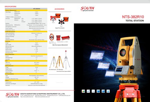
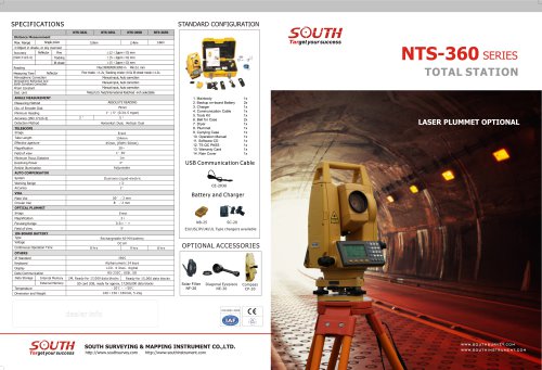
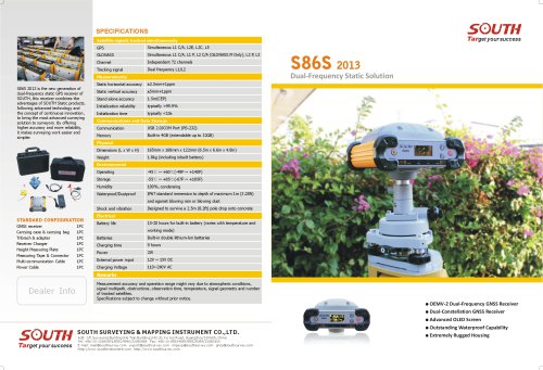
SPECIFICATIONS
Controller Part (Getac PS336 Lite)
Receiver Part
Measurements
General Info
- 220 channels, by advanced Pacific Crest Maxwell 6 Custom Survey GNSS
Technology
- High precision multiple correlator for GNSS pseudo range measurements
- Unfiltered, unsmoothed pseudo range measurements data for low noise, low
multipath error, low time domain correlation and high dynamic response
- Very low noise GNSS carrier phase measurements with 1mm precision in a
1Hz bandwidth
- Signal-to-Noise ratios reported in dB-Hz
- Proven Pacific Crest low elevation tracking technology
Satellite signals tracked simultaneously
- GPS: Simultaneous L1 C/A, L2E, L2C, L5
- GLONASS: Simultaneous L1 C/A, L1 P, L2 C/A (GLONASS M Only), L2 P
- SBAS: Simultaneous L1 C/A, L5
- Galileo: Simultaneous L1 BOC, E5A, E5B, E5AltBOC
- BDS: B1, B2
- QZSS: L1 C/A, L1 SAIF, L2C, L5
Code differential GNSS positioning
- Horizontal: 25cm+1ppm RMS
- Vertical: 50cm+1ppm RMS
- SBAS differential positioning accuracy: typically <5m 3DRMS
Static and FastStatic GNSS surveying
- Horizontal: 3mm+0.5ppm RMS
- Vertical: 5mm+0.5ppm RMS
Realtime Kinematic surveying
- Horizontal: 8mm+1ppm RMS
- Vertical: 15mm+1ppm RMS
- Initialization time: typically <8s
- Initialization reliability: typically >99.9%
Hardware
Physical
- Dimensions (L x W x H): 165mm x 168mm x 122mm (6.5in x 6.6in x 4.8in)
- Weight: 1.85kg (including inbuilt battery and inbuilt radio module)
Environmental
- Operating: -45°C ~ +60°C (-49F ~ +140F)
- Storage: -55°C ~ +85°C (-67F ~ +185F)
- Humidity: 100%, condensing
- Waterproof/Dustproof: IP67 standard immersion to depth of maximum 1m
(3.28ft) and against blowing rain or blowing dust
- Shock and vibration: Designed to survive a 2.5m (8.2ft) pole drop onto concrete
Electrical
- Power 12-15V DC external power input
- Rechargeable, 7.2V, 8800mAh Lithium-Ion battery units built in receiver
- Battery life: 15-20 hours for built-in battery (varies with temperature and
working mode)
Communications and Data Storage
- Standard USB2.0 port
- RS-232 port: Baud rates up to 115200
- Stollmann's BlueMod+B20 inside for Bluetooth function
- Fully sealed and integrated 2.4GHz communication Bluetooth port
- UHF receiving antenna port
- Fully sealed and integrated radio receiver/transmitter,0.5-2W adjustable, 410430/430-450/450-470MHz optional (default 0.5W, 450-470MHz)
UHF Range (varies with terrain / temperature): 3-5km typical, 8-10km optimal
- Mini GDL5 Radio (optional): 2/5W
UHF Range (varies with terrain / temperature): 4-6km typical, 8-10km optimal Standard GDL20 (optional): 25W
UHF Range (varies with terrain / temperature): 8-10km typical, 15-20km optimal
- Fully sealed and integrated internal GPRS/GSM module
- External cellphone support for GPRS/GSM (2G default, 3G optional) module for
network RTK (CORS) operations
Network RTK (via CORS) range (varies with temperature / GPRS data rate):
20-50km
- Data storage: internal flash memory 4GB (extendable up to 32GB)
- Recording Rate: 1Hz, 2Hz, 5Hz, 10Hz, 20Hz & up to 50Hz raw measurement &
positioning outputs (depends on installed option, default 1Hz)
- Reference outputs: CMR, CMR+, RTCM 2.1, RTCM 2.2, RTCM 2.3, RTCM 3.0,
RTCM 3.1
Platform
- TI AM3715 1GB Microprocessor
- 1GB Flash ROM
- 512MB MDDR Memory
- 256MB NAND Flash and 8GB iNAND
Operating System
- Windows Mobile 6.5
User Interface
- 3.5in VGA (480x640 pixel)
- 600 nits sunlight readable display
- Pressure sensitive touchscreen
- Nuance XT9 Soft input panel (SIP)
- Transcriber handwriting recognition
- Alpha/Numeric keypad
Communications
- WLAN 802.11 b/g/n
- Bluetooth (v2.1+EDR Class 2)
I/O Interfaces
- DC, USB OTG, RS232
- Office docking port, FlexiConnTM port
Power Management
- Battery: 3.7V, 5600mAh
- Li-lon battery pack
Environmental
- MIL-STD 810G certified
- IP68 certified, drop resistant (26 drops from 6ft/1.82m)
- Tumble resistant (1000 cycles; 0.5m/1.6ft)
- Optional ATEX zone 2/22
- Operating temperature: 22 F to 140 F (-30 C to 60 C)
- Storage temp temperature: 40 F to 158 F (-40 C to 70 C)
- 95% RH, Non-condensing
Physical
- Dimensions(LxWxH): 178mmx89mmx30mm (7inx3.5inx1.18in)
- Weight: 0.53kg
Target your success
S86
Integrated RTK GNSS
Surveying System
Remarks
Measurement accuracy and operation range might vary due to
atmospheric conditions, signal multipath, obstructions,
observation time, temperature, signal geometry and number of
tracked satellites.
Refer to separate brochure for more details of optional controller
models, SOUTH MasterPro Mobile S10.
Specifications subject to change without prior notice.
DEALER INFO
SOUTH SURVEYING & MAPPING INSTRUMENT CO.,LTD.
Target your success
Add: 2/F, Surveying Building (He Tian Building),NO.26, Ke Yun Road, Guangzhou 510665, China
Tel: +86-20-23380891/85524990/23380888 Fax: +86-20-85524889/85529089/23380800
E-mail: mail@southsurvey.com export@southsurvey.com impexp@south
survey.com gnss@southsurvey.com
http://www.southinstrument.com http://www.southsurvey.com
Make YES! Happen
"