عضویت
عضویت  ورود اعضا
 راهنمای خرید


Corridor Mapping0 pages
Corridor Mapping
ALTM Application Note: OR-001 Rev A
Lidar data
One inherent feature of lidar data is that it is acquired,
processed, and delivered in digital format. Lidar data can be
imported and exported by most commercially available 3D
software packages, including PLS-CADD, one of the most
common software packages for power line applications.
Lidar data collected in power line surveys typically includes
ground features, vegetation, structure attachment points and
conductor point clouds. Lidar data uploaded to PLS-CADD
enables the user to analyze sag, clearance, conductor physical
parameters and vegetation encroachment.
Dynamic range of intensity (12-bit)
Very thin linear targets (e.g., power wires) suspended close to
the ground present a demanding challenge for signal detection
capability. This is because weak returns from wires occur
alongside strong returns from the ground underneath. If
variations in the return signal exceed the dynamic range of the
lidar receiver, either weak signals from the wires will be missed
(data voids), or strong signals from the ground underneath will
saturate the receiver, compromising range measurement
accuracy owing to errors in the range measurements.
The Orion-C overcomes this challenge because its unique
receiver electronics system was designed with true 12-bit
intensity capture. This crucial capability ensures data accuracy
in surveys where strong variations in return signals are
expected—precisely the case in power line surveys.
Eye-safe operation
The Orion-C employs a 1.5 micron laser, which delivers eye-safe
operation at altitudes as low as 35 meters in densely populated
areas—a critical feature as low-altitude surveying is often
required for power line surveys.
SSD data storage
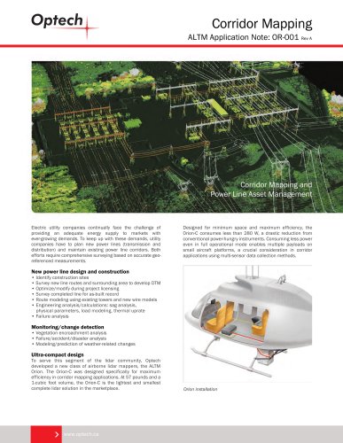
Corridor Mapping and
Power Line Asset Management
Power line and tower point cloud output from ALTM Orion-C data.
Data set reveals complete top wire detection, wire separation
within a 4-wire bundle, and detailed tower architecture delineation
for easy tower type detection.
ORION-C ADVANTAGES
High data collection rate and ground point density
Electric utility companies continually face the challenge of
providing an adequate energy supply to markets with
ever-growing demands. To keep up with these demands, utility
companies have to plan new power lines (transmission and
distribution) and maintain existing power line corridors. Both
efforts require comprehensive surveying based on accurate georeferenced measurements.
Designed for minimum space and maximum efficiency, the
Orion-C consumes less than 280 W, a drastic reduction from
conventional power-hungry instruments. Consuming less power
even in full operational mode enables multiple payloads on
small aircraft platforms, a crucial consideration in corridor
applications using multi-sensor data collection methods.
New power line design and construction
• Identify construction sites
• Survey new line routes and surrounding area to develop DTM
• Optimize/modify during project licensing
• Survey completed line for as-built record
• Route modeling using existing towers and new wire models
• Engineering analysis/calculations: sag analysis,
physical parameters, load modeling, thermal uprate
• Failure analysis
The Orion-C operates at effective data collection rates of up to
200,000 points per second (200 kHz). In combination with
programmable scan settings covering a 0-50° field-of-view
(FOV), the Orion-C provides fast and
efficient data collection
with a highly flexible
selection of ground
point densities,
which can be
optimized
specifically
for power line
surveying.
Power line data collected by ALTM Orion-C
Its unrivaled small size and lightweight configuration give the
Orion-C exceptional flexibility—quick to install in any type of
aerial vehicle, including helicopters, fixed-wing aircraft and
even UAV platforms. Fast-mounting, with minimal cabling and
easy to transport, the Orion-C delivers optimized and
cost-effective data collection missions.
Monitoring/change detection
• Vegetation encroachment analysis
• Failure/accident/disaster analysis
• Modeling/prediction of weather-related changes
Roll compensation
In surveys involving a complicated aircraft trajectory over highly
non-uniform terrain, it is essential that the scan FOV remain
aligned with the center of the scan line under the aircraft. The
Orion-C’s roll compensation feature automatically adjusts the
system’s FOV center as it scans the flight line, compensating for
deviations in aircraft roll, and enables the Orion-C to track the
corridor accurately.
Ultra-compact design
To serve this segment of the lidar community, Optech
developed a new class of airborne lidar mappers, the ALTM
Orion. The Orion-C was designed specifically for maximum
efficiency in corridor mapping applications. At 57 pounds and a
1-cubic foot volume, the Orion-C is the lightest and smallest
complete lidar solution in the marketplace.
The Orion-C uses an internal 256-GB solid state drive (SSD) with
a SATA II interface. The advantages of SSD over traditional HDD
include: high data integrity resistant to vibration, higher
tolerance to shock, and a wider operating temperature
range—conditions normally associated with helicopter installations. An additional external SATA II SSD offers added storage
flexibility for easy drive swapping and data archiving. It provides
a cost-effective, commercial solution when compared to a
traditional embedded HDD system.
Altitude: 950 m AGL
Laser pulse rate: 100 kHz
Scan frequency: 40 Hz
Aircraft velocity: 120 knots
Scan width: ± 20°
Top wire diameter: 10.4 mm (000 gauge)
High data accuracy
The Orion-C employs the most advanced rangefinder electronics and optics, delivering outstanding range accuracy and
precision, independent of laser sampling rates. The resulting
high-quality data features exceptional resolution for detailed
imaging of small objects such as power lines. The distribution of
a 3D point cloud of a power line conductor is now in the millimeter range instead of the centimeter range. This capability
translates to a significant increase in the accuracy of catenary
modeling in PLS-CADD, and consequently to more reliable
engineering calculations based on modeled catenary parameters.
Orion installation
Optech Incorporated
300 Interchange Way, Vaughan ON, Canada L4K 5Z8
Tel: +1 905 660 0808 Fax: +1 905 660 0829
www.optech.ca
www.optech.ca
© Optech Incorporated. E&OE. Information subject to change without notice. Printed in Canada. 110408
"