عضویت
عضویت  ورود اعضا
 راهنمای خرید


SOUTH Galaxy G60 pages

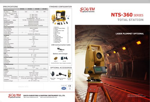
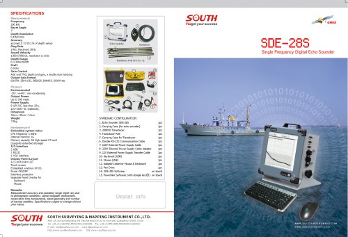
SPECIFICATIONS
Surveying performance | |||
Signal tracking | 220 channels | ||
BDS B1 > B2 | |||
GPS L1C/A, L1C, L2C, L2E, L5 | |||
GLONASS L1C/A, L1P, L2C/A, L2P, L3 | |||
SBAS L1C/A, L5 (iust for the satellites supporting L5) | |||
Galileo GIOVE-Aand GIOVE-B, E1, E5A, E5B | |||
QZSS, WAAS, MSAS, EGNOS, GAGAN (SBAS) | |||
GNSS features | Positioning output rate: 1 Hz~50Hz | ||
Initialization time: <10s | |||
Initialization reliability: >99.99% | |||
Positioning precision | |||
Code differential GNSS positioning | Horizontal: +0.25m + 1ppm | ||
Vertical: ±0.50m + 1ppm | |||
SBAS positioning accuracy: typically<5m 3DRMS | |||
Static GNSS surveying | ± (2.5mm + 0.5mm/km x d) (d: the distance between measured points, km) | ||
Real-time kinematic surveying | + (10mm + 1 mm/km x d) (d: the distance between measured points, km) | ||
Operation system/User interface | |||
Linux | |||
Button | Double buttons and visual operation interface | ||
LCD | 0.96 inch HD OLED screen, the resolution is 128 * 64 | ||
Web interaction | Visiting the internal management web page via WIFI or USB mode, to monitor the receiver | ||
status and change the configuration freely | |||
Voice | iVoice intelligent voice technology provides status and operation voice promptly | ||
Supporting Chinese, English, Korean, Russian, Portuguese, Spanish, Turkish | |||
Supporting user defined voice | |||
Secondary development | Providing secondary development package, and opening the OpenSIC observation data | ||
format and interface definition for secondary development | |||
Data cloud service | |||
Web page cloud service management platform, supporting online register etc. | |||
Dimension | 152mm (diameter) x 137mm(height) | ||
Weight | 1.44kg (including battery) | ||
Material | Magnesium alloy shell | ||
Temperature | Operating: -45° C - +60° C, Storage: -55° C ~ +85° C | ||
Humidity | 100% Non-condensing | ||
Protection Level | Waterproof: IP67 standard, protected from long time immersion to depth of 1m | ||
Dustproof: IP67 standard, fully protected against blowing dust | |||
Shock and vibration | Withstand 3 meters drop onto the cement ground naturally | ||
Electrical | 9-25v wide voltage DC design, with overvoltage protection | ||
Battery | High capacity removable battery with the indicator displaying the power usage | ||
Voltage 7.4v, 6800mAh/per | |||
Battery life | More than 30h (static mode), More than 15h (RTK mode), (Providing the 7 x 24h battery solution) | ||
Communications | |||
I/O port | 5PIN LEMO external power port + Rs232, 7PIN LEMO external USB (OTG) | ||
1 network/radio data link antenna port, SIM card slot | |||
Wireless modem | Integrated internal radio receiver and transmitter 1W/2W/3W | ||
External radio transmitter 5W/25W | |||
Working frequency 410-470MHz | |||
Communication protocol: TrimTalk450s, SOUTH | |||
Cellular mobile network | WCDMA3.5G network communication module, GPRS/EDGE compatible; | ||
CDMA2000/EVDO 3G and TDD-LTE, FDD-LTE 4G optional | |||
Double module Bluetooth | BLEBIuetooth 4.0 standard, support for android, ios cellphone connection, Bluetooth 2.1 + EDR standard | ||
WIFI | |||
WIFI hot spot | Adopting the WIFI hot spot function, any smart terminals (controller, cellphone and PC) can connect | ||
to the receiver easily | |||
WIFI data link | The receiver can transmit and receive correction via WiFi | ||
Data storage/ transmission | |||
Data storage | 8GB internal storage | ||
Supporting external USB data storage | |||
Changeable record interval, supports up to 50Hz raw data collection | |||
Data transmission | USB data transmission, FTP download, HTTP download | ||
Data format | Static data format: STH, Rinex2.x and Rinex3.x etc. | ||
Differential data format: CMR+, CMRx, RTCM 2.1, RTCM 2.3, RTCM 3.0, RTCM 3.1, RTCM 3.2 | |||
GPS output data format: NMEA0183, PJK plane coordinates, binary code, Trimble GSOF | |||
Network model support: VRS, FKP, MAC, supporting NTRIP protocol | |||
Inertial sensing system | |||
Tilt survey | Built-in tilt compensator, correcting coordinates automatically according to the tilt direction | ||
and angle of the centering rod | |||
Electronic bubble | Controller software display electronic bubble, checking leveling status of the centering rod real time | ||
Thermometer | Built-in thermometer sensors, adopting intelligent temperature control technology, monitoring and | ||
adjusting the receiver temperature in real time | |||
*~/\\M #T# M SOUTH SURVEYING & MAPPING INSTRUMENT CO.,LTD.
^^J^^J^^J m f f Add: 2/F, Surveying Building (He Tian Building),NO.26, KeYun Road, Guangzhou 510665, China
Tel: +86-20-23380891/85524990/23380888 Fax: +86-20-85524889/85529089/23380800
TUfQBtyOUTSUCCBSS E-mail: mail@southsurvey.com export@southsurvey.com impexp@southsurvey.com gnss@southsurvey.com
http://www.southinstrument.com http://www.southsurvey.com
Target yoursuccess
GALAXY G O
— Innovative GNSS Receiver —
I
"