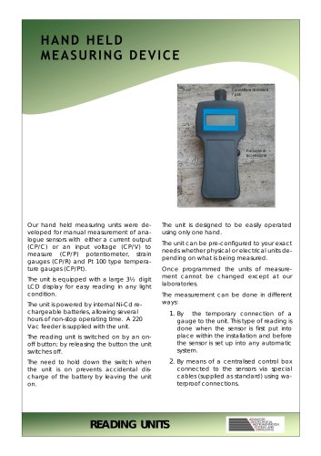
عضویت
عضویت  ورود اعضا
 راهنمای خرید


OVERSITE0 pages
OVERSITE
Oversite is a powerful software package for
data collection, storage and processing of
any reading taken on a site.
Oversite was developed to suit any project
site and has already been used for many
different applications.
By means of a
front-end driver fully
transparent to the user, Oversite can
acquire, at any frequency, automatic
readings coming from any sensor and
through any type of communication mode
such as a serial line, optical fibre, GSM,
coaxial cable, WiFi systems, even all of
them combined.
Last but not least Oversite can acquire
manual readings in Excel or Word files or
they can be loaded directly from the
keyboard.
Data is stored in a powerful and fast
georeferencing SQL server data bank fully
compatible with other georeferenced data
banks (GIS).
SOFTWARE
The data bank can be customised to suit
any site requirement with the creation of
instant screen views and dynamic tables for
quick and easy consultation.
By setting plausibility thresholds, even for
every single channel, Oversite can analyse
the data, in a totally automatic way, even
before their entry in the data bank.
The control and management of readings
by the user was designed to be the most
quick and friendly possible.
Data retrieval is achieved just like surfing on
a website.
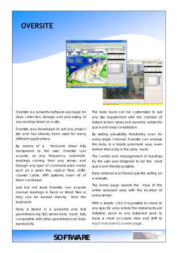
The home page reports the
map of the
entire surveyed area with the location of
every sensor.
With a simple click it is possible to move to
any specific area where the instruments are
installed, zoom to any restricted zone to
have a more accurate view and shift to
each instrument’s screen page.